14th Science Apéro

Orbiting Research Stations – Satellites Serving Science

04.11.2003 | REMIGIUS NIDERÖST
As high-tech observation platforms in space, satellites have long provided unique opportunities for scientific research. In future, thanks to innovative new measurement instrumentation they will be able to deliver even better quality data, for use, for example, in generating more accurate long term weather forecasts, in providing more precise position determination for terrestrial surveying, and for improving atmospheric analysis.
/documents/56164/318676/a592-2003-10-23-b5x_esa.jpg/b3533cc3-b74d-4a36-b212-1ab74410e549?version=1.0&t=1448308791768
Source: ESA
 
Hans-Peter Roesli of MeteoSchweiz making his presentation at the EMPA Academy
 

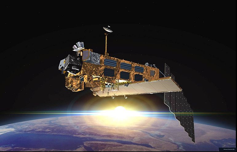
Satellites for weather and climate monitoring
The Swiss national weather service has been using satellite technology to generate weather forecasts since data became available in the early 60’s. The “Meteosat” series of satellites, first launched in 1977 deliver extremely good images in comparison with their predecessors. These images are taken not only at the visible wavelengths but also in the infra-red range of the spectrum, as Hans-Peter Roesli of MeteoSchweiz reported at the Science Apèro. An important factor affecting weather development is the water vapor which envelops the Earth, and which satellites have made “visible”. The Meteosat satellite currently in operation is the seventh of the first generation, and it transmits an image to the ground station every 30 minutes. In 2005 it will be replaced by a satellite of the second generation, which transmit a still-better quality image every 15 minutes.

Today, meteorologists have about ten times more data available for use in making forecasts than in 1977. This data is not only used for short-term forecasts but also for wind measurements, which are important for medium term forecasting. In addition, Meteosat data is also used for global weather observations and as a part of the fundamental input from which well-founded statements on climate change can be derived.
However, according to Roesli, data from ground stations, in addition to that from satellites, is still essential for spot-on weather forecasts and this will remain so in future too.

 
Elmar Brockmann of Swisstopo
  The Global Positioning System (GPS) serves terrestrial surveying
The second speaker, Dr. Elmar Brockmann of the Swiss Federal Office of Topography (Swisstopo) in Bern, introduced the GPS system to the audience in the EMPA Academy. Created by the United States for military purposes in the 1980’s, data from this satellite network is now available to civilian users too. According to Dr. Brockmann, the use of GPS since 1987 has revolutionized land surveying, and has rendered obsolete the previous technique of triangulation (where angular measurements are made between points of elevation). Today, a network of reference stations distributed over the entire country supplies data every second to the main unit at Swisstopo. One such reference point in the AGNES network (as it is known) is located on the Jungfraujoch. Swisstopo utilizes the positional data from AGNES, which is also available to private users, for cartographic purposes, among others. As a result, today the position of practically any point in Switzerland can be determined with an accuracy of about one centimeter. An important benefit of this capability is, for example, the accurate positioning of boundary marker stones.
 
Daniel Schaub, EMPA, looking forward to the new generation of satellites, which will deliver data with higher spatial and temporal resolution
 

Air quality measurements from space
The third presentation by EMPA’s Daniel Schaub gave an insight into how EMPA uses data gathered by satellites in the evaluation and long-term monitoring of the air pollution situation in Switzerland. Satellite data is combined with terrestrial measurements, made by the National Air Pollution Monitoring Network (NABEL), enabling EMPA to assess the effectiveness of regulatory measures taken to improve air quality.
Pollutant transport by the wind is also of great interest, since it is possible by this means for emissions to be carried all the way around the world within a period of a few days. Daniel Schaub and his colleagues in EMPA’s Air Pollution / Environmental Technology Laboratory therefore also take on the task of Pollution Tracing, the determination of the sources of pollution. To achieve this they combine air transport data with that from satellites and the NABEL network and process it to generate so-called Backward Trajectories. This shows the path taken by a body of air over, for example, the last 24 hours. In the past this has enabled both the Ruhr Basin and the Po Valley to be identified as the sources of polluted air later transported to Switzerland. Daniel Schaub also looked forward to future improvements in satellite technology providing enhanced data quality in terms of better temporal and spatial resolution.

Those who think that each scientific discipline has its own satellite in orbit and need only worry about its own small patch need to think again. Satellites often collect data, which is not solely of use to a single scientific principal. As an example of this, Swisstopo provides data to both MeteoSchweiz and EMPA, and vice versa.